Every day's a school day, so the saying goes.
My wheels were in for an MOT at a garage in the Peak District village of Dove Holes. Students of stone age archaeology may be familiar with the Bull Ring henge in the centre. Now surrounded by the village school and a housing development.
 |
| Combs Moss - north (OS Maps subscription) |
With a couple of hours to pass the time, I went for a walk up to Combs Moss. It was an opportunity to visit a handful of sites which I'm not usually nearby in the course of my work. These were not the iconic places that Peak District archaeology is better known for, such as the Nine Ladies and Arbor Low Stone Circles. But the diminutive, the easily missed. With just a gothic script on the map to indicate that at one time, several thousand years ago, they were imbued with meaning and memory.
 |
| Cow Low |
The first location was Cow Low. A bronze age burial mound (c 2350 to 701 BC)
 |
| Cow Low (OS Maps subscription) |
Cow Low appeared indistinct on the approach. Its diameter is around 27 metres. The height, now 1 metre, is much reduced since the Bronze age.
The barrow itself has a depression in it's top, indicating it had once been dug out. According to information on megalithic.co.uk and Derbyshire Monument Record MDR203: Thomas Bateman excavated Cow Low and found a hexagonal cist containing two skeletons and food vessel. He published his book, Bateman's Ten Year Digging - where he describes excavating in 1846 and finding a number of cist burials.
 |
| Cow Low |
It was only standing atop the burial mound that a more complex set of earth works was revealed. Three circular tiered terraces on the steeper side of the hill. These were probably later features, possibly dug to source stone for walling at the time of the Enclosures Acts.
In contrast to the December halcyon day before, the weather had turned overnight. From early morning onward, the cloud base had descended. Bringing a water saturated mist which turned to rain the higher I walked and was ultimately supplemented with a gusty breeze.
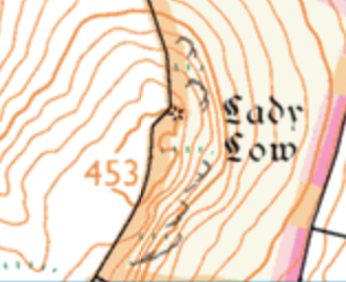
Next, I ascended to the top of the spur to find Lady Low. Another bronze age burial mound.
 |
| Lady Low (OS Maps subscription) |
This round barrow is 20 metres diameter and 2 metres high. It showed similar signs of disturbance to Cow Low, although there are no surviving known documents of excavation.
 |
| Lady Low |
I then just had enough time to gain the upper edge of Combs Moss and handrail the plateau around to Castle Naze. An iron age hillfort with natural cliffs on the north and south west sides.
 |
| Castle Naze (OS Maps subscription) |
The defensive ramparts, double row ditches, bisecting the far north west corner of the plateau are still very evident. When freshly cut and embellished with palisades, they would have been a formidable obstacle to would-be aggressors.
 |
| Castle Naze ramparts |
I looked over the steep face of the Short Edge, through a brief parting of the mist. Below, I saw a colour change in vegetation. A distinct linear shape. That looked like another ditch, I thought. Cross checking the map this was confirmed by chevron earthwork symbols. Further research showed this to be an ascending hollow way, which forms a defensible access to the hill fort.
 |
| J.D.Sainter's plan of Combs moss Hillfort aka Castle Naze (1878) |
According to Megalithic.co.uk: It was surveyed in 1957 by students from a Nottingham University summer school and The Workers' Educational Association of Buxton, when it was established that the fort had undergone three phases of construction, two of the Iron Age and one Medieval. Obvious differences in the method of construction confirmed that the two prehistoric phases were not contemporary.
 |
| Castle Naze aerial photo - Google Maps |
It was time to go and I retraced my route. I thought about what route the people that used the fort would have taken. Features in the landscape commonly continue to serve as reference point, even when their original meaning or significance has changed.
 |
| Catle Naze ramparts ditch |
Archaeologists often refer to the ritual landscape. But perhaps too readily, things that elude understanding are put into the ritual category. Phenomenology techniques have helped modern archaeologists make better sense of the sites they are studying. More than what's possible by just looking a two dimensional maps. By actually being within the environment and using cues for all the senses, one can achieve a deeper level of insight into how people interacted with their landscape.
 |
| Possible trackway, eastern side of Combs Moss |
As I walked off the east side of plateau, I didn't think ooh, lets now do some phenomenology. But I did notice what first appeared to be a shallow ditch, with small puddles under sprigs of heather reflecting the grey sky. The ditch widened further and followed the natural line of descent. Not straight down, but contouring, easing the gradient. Aside from a couple of very subtle deviations on contour lines, it wasn't shown on the map. Although it was in common with the natural line I was taking and also heading towards the lower ground and direction of Dove Holes.
The realisation sprang to mind, that I was perhaps following another trackway ramp. For the Iron Age communities below the eastern side of the plateau to access the defensible structures on higher ground.
From a day of undemanding expectations and claggy mist, I carried home this little gem of insight.
