Sunday 22 May 2022

#065 In search of the Stone Age - Phenomena

Situated on and around Kilmartin Glen is an astonishing concentration of Neolithic and Bronze Age monuments, including standing stones, a henge, numerous cists and a linear cemetary comprising five burial cairns.

Indeed, there are so many that in trying to see as much as possible the visitor might flit from one to the next. Thereby missing a sense of place, the interrelation of monuments and how they fit within the environment. 

Image: Stu Westfield 

Anyone that has ever journeyed on a lower Nile cruise will understand. The week begins as a feast for the eyes, as you experience the wonder at what the pharaohs and ancient Egyptian society achieved all those millennia ago. By the end of the trip, it's all too easy to feel 'all tombed out'. To preserve the initial magic, its helpful not to cram too much in, but to pick and choose. Also to look away from the obvious eye-catching attraction of the monuments and enjoy the view.

With a relatively short time available, I took the same approach to Kilmartin Glen. Selecting a handful of accessible sites, each with a particular interesting feature or reason to visit and see.

We will also be looking at evidence of how monument style, culture and funerary practice changed within Kilmartin Glen from the late Mesolithic to Bronze Age. So it's worth sharing a timeline for additional context. It's important to remember when referencing any timeline to look at both the date and location. The Neolithic and Bronze age transitions, often called 'revolutions' occurred through migration of people, ideas, culture and portable items.

Credit: Kim Biddulph - Prehistory blog


Dunchraigaig Cairn
This was my first stop. Just across the road from a visitor car park. It was unusual in that it has three cists inside, each with a different style of inhumation. (A cist is a burial chamber made from stone).

Image: Historic Scotland visitor information board

The cist to the east contained only cremated bones. The central cist contained a full-length body on top of its cover slab, with cremated human bones inside and below this a layer of rough paving which revealed yet another body, in a crouched position.

Image: Stu Westfield

But the third cist, on the south-east side was the most unusual. Dug directly into the ground, lined with drystone cobbled walls and capped with a massive stone, it contained the remains of up to 10 individuals, some cremated and some not. It also held a whetstone, a greenstone axe and a flint knife.

Image: Stu Westfield

While cairns often became the burial place of more than one individual, it is rare to find so many individuals in one cist. Bronze Age cist burials, like this one, were usually reserved for one person – multiple burials are more often seen in Neolithic tombs. (source Historic Scotland)

Credit: Guillaume Robert, University of Edinburgh

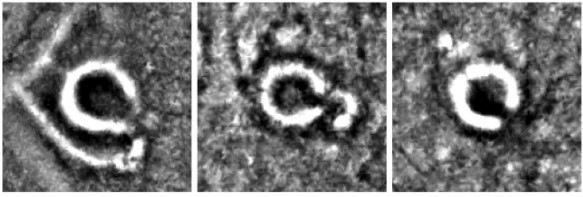
At the time of visiting, the south-east cist had been sealed off to protect a chance rediscovery of deer carvings on the underside of the cap stone. Dating back to the early Bronze age, deer carvings are rare. Most rock art dating from this this period in Scotland is cup and ring marks. While prehistoric animal carvings are known in Europe, this fresh discovery in Britain offers new insight and challenges assumptions about culture and migration in this period.

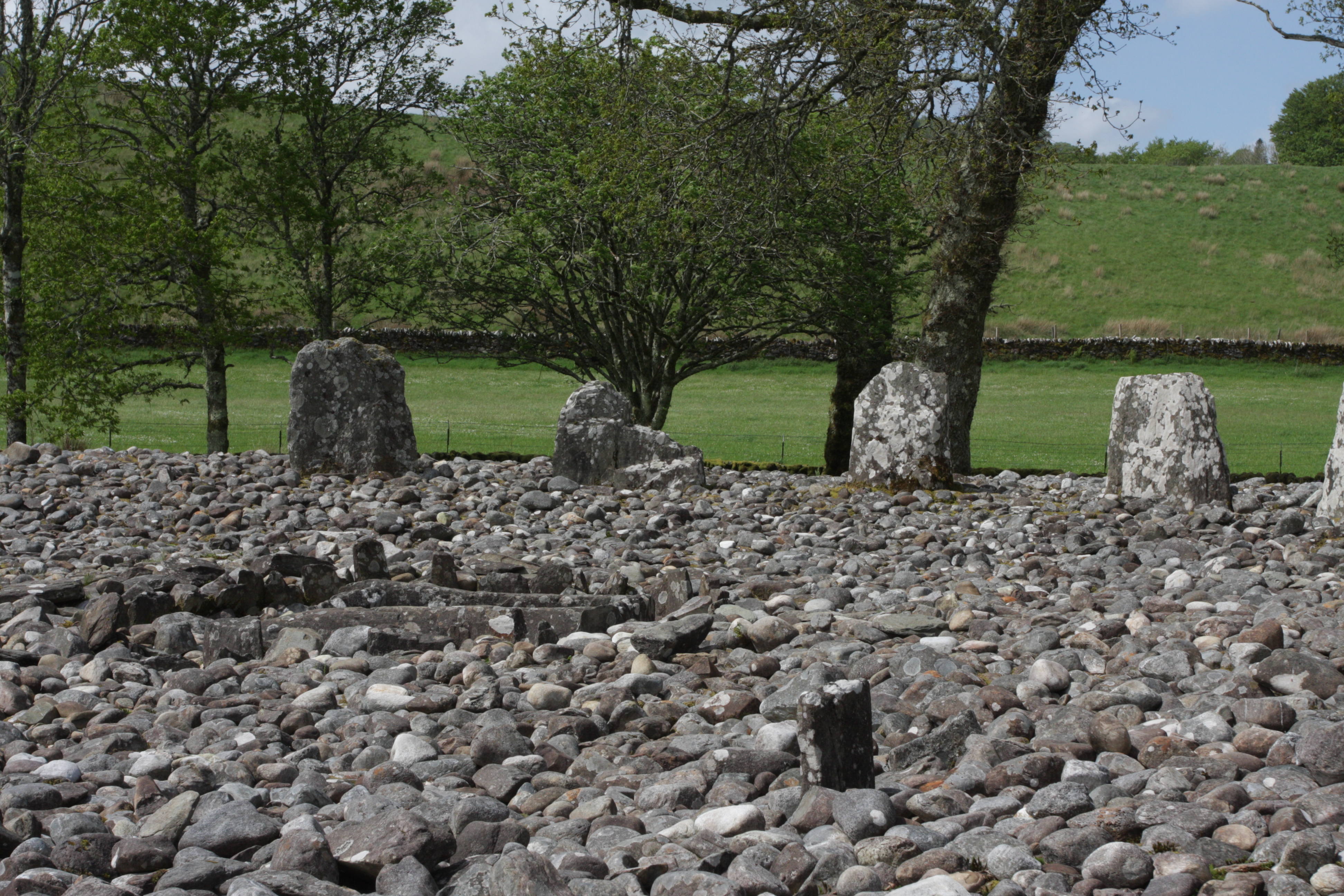
Nether Largie Standing Stones
Stone circles and standing stones are an ongoing topic of research and debate regarding their significance in terms of celestial alignments. Stonehenge, for example, has long since been associated with the summer solstice sunrise. 

Stonehenge alignments: Source Stonehenge Tours

But archaeologists now believe that the diametrically opposite alignment to the mid-winter sunset was of primary importance, signifying the sun's rebirth and a new cycle of farming activity. 

Greater discussion of this topic is given in the Stonehenge Tours blog:
https://www.stonehenge-tours.com/blog.Astronomical-Alignments-at-Stonehenge.html

Image: Stu Westfield

Research on the the Nether Largie set supports interpretations as both a solar and lunar observatory. The stones mark where the moon rises and sets at key points in its 18.6 year cycle. They also align with the midwinter sunrise as well as the autumn and spring equinox sunset.

Image: Stu Westfield

The Nether Largie stones were erected about 3200 years ago. However, three of the stones are decorated with cup marks and rings, which typically date from 1500 years earlier. Indicating that the standing stones were probably cut from previously decorated rocky outcrops, like those at Achnabreck. A site which we shall return to later. 

Image: Stu Westfield

The slanted top of the tallest stone is a feature which we have seen in circles on Arran and Orkney. The pleasing aesthetic of this cleaving line as it points to the sky is undeniable. With such a detailed level of planning and intent for the purpose of the stones it would be remarkable if this characteristic was not particularly sought out in the selection of raw materials. 

Temple Wood Stone Circles
Walking among the various sites in Kilmartin Glen, they all share a significant sense of being rooted in the landscape. The surrounding hills, nearby river and flat valley bottom are all in common with other ancient sites I have seen in Arran and on the Isle Of Mull. These monuments are a projection of status, cultural identity and perhaps power. Acting as an influence upon the behaviour and compliance of the local habitants. As well to impress, even intimidate, visiting tribespeople causing them to think:

'Here is a well organised community. Look at their splendid interactions with the sky. Their reverence for those which have gone beyond to join the ancestors.  Our journey to this place is significant and meaningful. We should be friends with them. We wish to make our contribution to the celebration of ancestors. Our people could also trade with them. We should seek joining of relations for our sons and daughters. Together we will be strong.'

Or they may have coveted what they saw and with duplicity and guile, overcome and placed themselves in the ruling seat. 

Southern circle. Image: Stu Westfield

On first appearance, the Temple Wood stone circles have more in common with a kerb cairn. Like the Moss Farm Road cairn seen at Machrie Moor on Arran. The larger southern circle, has an obvious cist structure at its centre. Both have rounded cobbles graded to size as an infill. With larger cobbles added as an outer ring on the southern circle. 

Southern circle cist detail, dating to 4000 years ago. Image: Stu Westfield

Archaeology had given us a 2000 year timeline, during which the circles went through several phases of use. Beginning 5000 years ago with a timber circle on the northern site, which was soon replaced with stones and the second southern circle was built. Phosphate analysis, shows that about 4200 years ago a cist just outside the southern circle was used as a burial. The inhumation accompanied by a beaker and arrowhead. 

Temple Wood circles timeline. Historic Scotland information board.

The two cairns built inside the southern circle, around 3300 years ago, have small stone 'false portals' at right angles to their kerbs. Both these fake entrances face southeast, towards the midwinter moonrise. (Source: Historic Scotland information board). 

Northern circle, with a splash of spring bluebell colour. Image: Stu Westfield.

A similar false portal cairn is located near to the stone circle at Lochbuie on the Isle Of Mull. In our film Neolithic Mull we describe the lunar impression an infill disc of fresh, gleaming white cobbles would have upon those seeing the tomb, before it had weathered into the landscape. 

Link to Ranger Expeditions' Neolithic Mull film (false portal kerb cairn at 3min 14sec):
https://www.youtube.com/watch?v=2gTPH8KER0s&t=592s

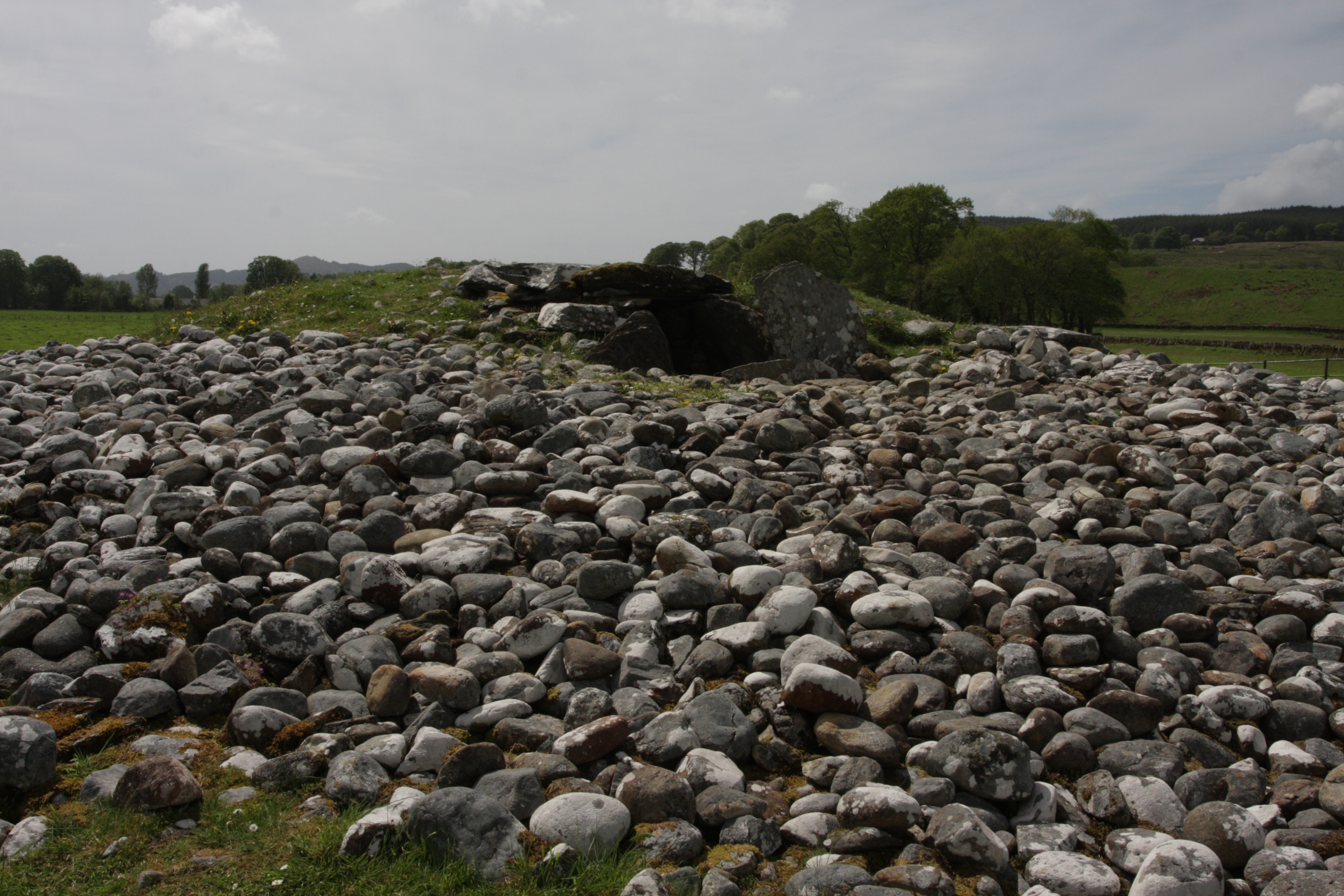
Nether Largie South Cairn

Image: Stu Westfield

This Neolithic chambered tomb is one of the earliest monuments in Kilmartin Glen, build around 5500 years ago. Typically chambered tombs were originally used as bone repositories, possibly after the body had been excarnated (de-fleshed) in the open. 

Historic Scotland information board.

Maybe with the aid of animals such as sea eagles, other birds or dogs, if the totemic evidence in contemporary Orcadian tombs can be translated to Kilmartin Glen. The bones were then disarticulated, sorted and interred within the chambers. 

Chamber entrance. Image: Stu Westfield

Chamber. Image: Stu Westfield

However, later ritual practice, is evident at Nether Largie South. Around 4300 years ago people reused the tomb for burial, also placing pots and flint arrowheads with the dead inside the chamber. Then, a few generations later in the early bronze age, they re-modelled the tomb. Converting it into a circular cairn like the others along the valley bottom. Two stone cist graves were added. (source: Historic Scotland, information board)

Nether Largie South tomb contents. Source: Historic Scotland

Cist structure. Image: Stu Westfield

Achnabreck Rock Art
Just 8 miles south from Kilmartin Glen is Achnabreck, the site of some of the most prolific and impressive prehistoric rock art in Britain. 

Image: Stu Westfield

The use of landscape at Achnabreck appears to be very different to the Kilmartin context. The monuments at the glen draw people in from the surroundings. Whereas the Achnabreck location is on high ground overlooking the valley between Lochgiphead and Cairnbaan. The cup and ring marks seem to project outwards.

The use of psychotropic substances in rites of passage is common among indigenous communities around the globe. It's not a great stretch to presume that our ancient ancestors used shamanism to induce trance and altered states of mind during ritual activities. They certainly would have had an intimate knowledge of which plants were good to eat, which were toxic and which could be used to produce hallucinogen like effects. 

Image: Stu Westfield

The designs at Achnabreck were created between 5500 and 4500 year ago, during the later Neolithic. They look the most remarkable when the sun is low. Among the most remarkable are seven concentric rings 1 metre across on the middle outcrop and the double spirals on the upper outcrop. Some designs seem to run in parallel to the cracks and fissures in the rock, which are naturally aligned to the midwinter sunset. (Source: Historic Scotland information board)

But what to these symbols mean? Why did people take time to carefully peck these motifs into solid bedrock? And why was it necessary to repeat the exercise numerous times? The lower Achnabreck surface contains 83 symbols, while there are more than 100 on the upper outcrop.

Image: Stu Westfield

More than 3000 panels of rock are have been found in Scotland, while thousands of prehistoric carvings are occur along Europe's Atlantic fringe. The common symbols hint at shared knowledge and beliefs among people that created them. (Source: Historic Scotland information board)

There have been many theories as to their meaning. Some more outlandish than others and quite a few which are frankly ridiculous and belong in the pages of science fiction comics. One of the more plausible which is backed up by experimental reconstruction, is that the symbols are an artefact of the mind, created when either under the influence of, or remembering, a shamanic type experience.

Image: Stu Westfield

We have explored this concept previously when looking at the the markings etched on a mesolithic pendant from Star Carr, Yorkshire. 

http://stuwestfield.blogspot.com/2020/05/044-recreating-star-carr-mesolithic.html

Mesolithic hunter gatherers and Neolithic farmers had different ways of life and culture. There is a possibility that shamanic etchings are a cultural carry-over, but this presumes the Neolithic revolution absorbed and integrated with hunter gatherer societies. The DNA evidence does not always bear this out. Comparative studies of ancient British hunter gatherer skeletal DNA with Neolithic remains, show that the immigrant continental Neolithic farmers replaced the indigenous hunter gatherer populations.

Interestingly DNA analysis of the next major cultural change - the arrival of the Beaker People, which signified the end of the Neolithic and beginning of the bronze age - showed that more than 90% of Britain's Neolithic gene pool was replaced by people related to the Beaker people of the lower Rhine at the start of the bronze age.  

Credit: D Lewis-Williams & D Pearce 

In their book Inside the Neolithic Mind, Professor David Lewis-Williams and David Pearce propose that the fundamental shapes stem from the deep consciousness of homo-sapiens as a species. Hence, they have commonality across continents and millennia, with stylistic differences influenced by and attributed to local or contemporary culture.

However, to us, the enigma is what did these symbols represent in the consciousness and cosmology of Neolithic people? Monument structure and styles, funerary practice and portable artefacts can lead us to speculation and a best guess. We are looking back as if through a frosted window and we may never know is what rituals, rites of passage or ceremonies, prompted the creation of these symbols.

The Stone Age Re-Crafted In Hayfield

I have recreated a range of stone age motifs from the ancient past. Inspired by the distant paleolithic, through the continental and British Neolithic, bronze age and into the Viking era. Some pieces are fashioned into tea light holders, all are distinctive and highly decorative.

https://rangerexped.co.uk/index.php/stone-age-crafts/


Stu Westfield
Ranger Expeditions - Trek Leader


Guided experiences & challenge walks

Peak District 3 Peaks Challenge
Edale Skyline Challenge
Kinder Scout Sunrise Breakfast Experience
Kinder Scout Supermoon Special
Kinder Scout Winter Wonders

Ranger Ultras
low-key, big-enjoyment, great-value, trail-running


Tuesday 17 May 2022

#064 Ranger Ultras - Footwear and kit survey - PB270 Pennine Bridleway Trail Challenge

The inaugural PB270 Pennine Bridleway Trail Challenge is complete and we're delighted with how it went. There's been lots of great positive feedback, support and interest, for which we're hugely grateful.

The pioneering year 1 athletes enjoyed the challenges of the trail as well as the checkpoints, safety, hospitality and other infrastructure we put in place. Our take-away points from their feedback was that it was just the right amount of support and safety cover, but never too intrusive to diminish the sense of journeying and adventure. Also that the menu and selection of meals was very tasty.

The food selection was something I took a lot of time to get right. I wanted to offer something fulfilling and nutritious, whilst fresh and different in style. The East African rice and beans (mwali na maharage) was a nod to where the inspiration for Ranger Expeditions & Ultras all began, back in Tanzania twelve year ago. Next year, I've plans to upgrade the checkpoint coffee from instant americano to the proper stuff. 

Both athletes and the Ranger Ultras Safety Team (RUSTies) commented that the PB270 is certainly an achievable proposition. But the results show that it is a real challenge and definitely no 'gimme' or  foregone conclusion. With the generous timings it is an inclusive race for participants with walk-jog strategies as well as extremely runnable trails for athletes going for a place. The scenery is varied, with plenty of countryside and open moorland. 


When setting out our stall for the PB270, we aimed to offer an original, long distance trail running event on the iconic Pennine Bridleway. Striking a sustainable balance between quality, value and low key impact upon the environment and communities. We also wanted the finish to be worthy of athletes achievement with a celebration in a lovely venue accompanied by a hot meal and bed to rest.


In the current economic climate, where many hard-working folks leisure budget is being eaten away by ever increasing domestic bills, it seems even more timely that we should offer multi-day trail running which doesn't cost thousands of pounds to enter. 

It's these combination of factors which has guided us to set the 2023 entry at a maximum of 40 participants. With this number I'm confident, as a team, we can roll out the same level of quality, service and experience to each runner. While team members equally enjoy the camaraderie and a fulfilling time with fellow RUSTies. 


Si-Entries to the 2023 edition are now open...
We look forward to welcoming you to a great second edition of PB270 trail running.

https://www.sientries.co.uk/event.php?event_id=9900

In the media...
These excellent reports and podcasts featured the 2022 PB270...

Run Ultra - Editor Katie Allen, has collated reviews and thoughts from athletes (including the winner Bobby Cullen) and members of the Ranger Ultras' Safety Team (RUSTies) in the following feature A Race Of Many Firsts...

https://run-ultra.com/news/a-race-of-many-firsts/

Martin Slack (3rd place finisher) interview with Kev Robinson from Running Your Stories...

https://www.youtube.com/watch?v=3KtHRZWtBoE


The Survey

We asked 2022 PB270 starters to share their thoughts behind kit selection and in retrospect what they might do differently next time. I've collated the answers from both DNF as well as finishers. Naturally, choice of kit, clothing and footwear is subjective and personal. Ideally, any item should be tried and tested in similar circumstances (eg prolonged wear, weather, terrain) before it is considered fit for purpose. The intention here is to help future PB270 participants develop their own race finishing strategies. 

For context: The weather during the 2022 PB270 was dry. Temperature ranged from warm during the day to cold at night. The trail is predominantly well defined with consolidated surfaces. Grassy sections were dry. Very little bog or muddy sections. Questionnaire respondents 1) 2) & 3) were finishers, 4) 5) 6) & 7) DNF. 

Footwear:
What shoe / sock combo did you use on the PB270?
Will you use these again in 2023? Or, if not will you be changing to something different?

1) Two pairs of Scott's, changed to larger half way. Socks, a mixture of Injiji merino and Bridgedale. I had waterproof socks with me but did not use them. I'd go with the same again next time.
2) Karrimoor trail shoes, anti-blister socks which I'd recommend.
3) I bought Scott Supetrac 3 as I'd imagined hard bridleway surface. I intended to use them for the whole PB race. At Hebden I decided to change to a pair of Inov8 road shoes for a change. They got quite wet in the fields after Gisburn but were otherwise good for the purpose. I changed back to the Scotts for the last leg. I'd wear then again next year.
4) Hoka Speedgoat / Mafeate with Injiji liner and med weight trail socks. This suited me on the harder Pennine Bridleway trail. If the weather was too warm, I'd not wear anything over he Injiji to reduce sweating.
5) Inov8 Rocklites with Injiji ultra socks and vaseline on feet. Never had a blister of foot issues.
6) Topo Ultraventure 2 with long Injiji and twin skin socks. Maybe slight overkill but feet were fine.
7) Inov8 Terra Ultra G270 with Injiji socks. I'll be using these again in 2023.

Rucksack:
Which did you use on the PB270?
Will you be changing this?

1) Ultimate Direction 30 litre, very happy with it.
2) Montane Trailblazer 18. My side pockets were not easily accessible without taking the pack off. I'd recommend at least a 20 litre backpack. 
3) OMM 25 litre. I'll stick with this in 2023. Good for the job.
4) Montane Via 20 lite. Good size and comfortable. I'd wear this again.
5) OMM Classic 25 litre. Will probably use again.
6) Geko 20. But too much weight on my dodgy shoulder I plan on using Raidlight with a waist strap next year. Wish I had a larger waist pack with water carrier and front carrier for charging, holding map, easy eating etc
7) Salomon XA25. I'll use this again next year.

Bivvy:
Did you bivvy out? How did this go for you in terms of kit choice and warmth?
If you didn't bivvy out did you wish you had done?

1) Two bivvies. First, 1 hour, shoes off, sleeping bag + bivvy bag, slept well. Second, 45 mins, shoes on, bivvy bag + extra clothes + mat. Cold on waking, but moving within 5 mins.
2) I took a basic Mountain Warehouse bivvy which worked well for the time of year and weight considerations.
3) I quite often sleep out on the course. My original intention was to get in and out of Hebden then bivvy for a sleep cycle around Gorple reservoir. But I was quite exhausted and decided to sleep for 1.5 hours at CP2. I slept for 15 mins not long after the Cam Road, just wearing my trousers and coat.
4) I never bivvy out unless it is an emergency
5) Didn't bivvy out but would have done if make it past CP2
6) Had a nap in Alpkit Hunka. Previously used in combo with 2 season sleeping bag and Alpkit mat, it was quite cool. I'm thinking that a bivvy at the end of the Cam Road (Pennine Bridleway - ed.) might be cold.
7) Didn't bivvy out. I didn't feel the need to and it's more comfortable in the checkpoints.


Generally:
What items of kit worked well for you?
And what items didn't?
Do you wish you had carried/brought more, or less?
If you were to change your strategy what would you do and why?

1) Generally very happy with choices. Macadamia nut mix, nice for days 1 and 2, but made mouth sore on day 3. Good points: Garmin Fenix 6 Pro watch, shoes, rucksack, lightweight poles. I had a transition checklist at checkpoints, that worked really well.
2) Haglofs insulated jacket was pretty lightweight, which was necessary given the size of my pack! I should have taken a baseball cap (for the sun - ed.) as well as winter cap and gloves. Also mittens for when my hands were swollen. Extreme cold gloves were overkill for the time of year. Having headtorches which were both battery based would have been a better choice. Not getting dragged into other runners strategies is hard not to do. I should have set off slower at the start. Given more time, I would have reccied more of the course.
3) Shoe change was psychological. In the cold high winds with full sun, I wore full length tights, shorts, base layer and a warm layer. Which also helped not getting too sun burned (hood up). It was very odd weather. This would not have worked if there was not the cold high wind. I had everything I needed to keep warm. I should have kept on top of my water intake, but was ok. I could have used streams. Conditions were such that I carried too much food, greater than the 2000 calories.
4) All my kit worked well and unlike the Spine I didn't feel my pack was heavy. GPS unit fastened to my shoulder strap and reading glasses around my neck. But this didn't work well as too much to get tangled. I believe GPS watches are much easier to use, but I'm not spending 6 or 7 hundred quid on a watch. My strategy was simply to finish, so I'm determined to have another go.
5) Inov8 mid layer and shorts. Comfy not issues. Montane Fleet jacket at night kept the wind out and warm. Black Diamond poles, highly recommended for those hills. I was happy with my kit, but will explore ways to lighten the load. I need to change my strategy to adapt to fueling on the run for a multi-dayer. If sunny, taking breaks in the shade to cool off and hydrate. At checkpoint, organise packs in drop bag into socks, food, batteries etc to change. Checklist, to charge phone & watch on arrival, before food & drink. Check weather forecast, sort clothes, change footwear and freshen up before the next stage. Hopefully this will keep me focused and ensure a smooth transition. In preparation, probably recce more of the course, although I do like an adventure into the unknown. Oh and request a stair lift is installed for the gentle hill up from CP2 
6) North Ridge merino top and technical tee, with Montane Icarus and Montane Goretex jackets. Perfect for warmth as far as I got. Grateful for Montane ladies running gloves at night. I did need all the water I was carrying as few water sources or shops open when I was passing. Safety team water and snacks were very helpful. Followed the kit list almost exactly, adding sun cream which was perfect.
7) Mandatory kit was spot on for the cold nights and warm days. Using long sleeves and trousers avoided sunburn, taking extra care with the sun (despite sometimes feeling a bit hot) and at night didn't have to change to warmer clothes. Carrying poles sometimes felt like extra weight which wasn't really needed most of the route. I was carrying Montane Icarus and a down jacket which I never used both at the same time, but did so as thinking about safety in case I had to stop for a long period of time. Next time I'd change my strategy to sleep less at Checkpoint 2, where I had my first sleep (7 hours felt a bit of a waste of time). 

Summary

Several useful themes come out of the survey: Centering upon how a little preparation buys a lot of time during the race: Having kit within the drop bag sorted into different stuff sacks to transfer into the race pack at each checkpoint. A crib sheet for efficient transitions. Testing kit in advance. And some selective course reccies. Speaking of which, we have published some reccie notes to help future participants. We intend to add more, so that the whole course has a written up recce resource...

Pennine Bridleway, walkers alternative route around Glossop (avoiding roads)
http://stuwestfield.blogspot.com/2022/01/061-glossop-recce-ranger-ultras-pennine.html

Pennine Bridleway, CP2 Hebden Bridge to Wycoller
http://stuwestfield.blogspot.com/2022/03/062-hebden-to-wycoller-recce-ranger.html

Regarding kit choice, a race pack of 20 litres or more is required. And also, Injiji socks are very popular.

A big thanks to all respondents for sharing their race experience with us. I'm sure this will be an excellent starting resource for future PB270 runners. For folks who didn't make the finish this time, all the team look forward to seeing you again and have the pleasure of celebrating a much earned and deserved finisher's PB270 eco-coaster medal.

Ranger Ultras' offer an selection of trail running events which are excellent preparation for the PB270 and several include sections of the Pennine Bridleway which give the two-for-one bonus of entering a race and reccying at the same time. Do check out our webpage for more details.

http://rangerultras.co.uk/

Happy trails 
Stu Westfield
Ranger Ultras, Race Organiser


Friday 13 May 2022

#063 In search of the stone age - Ancient Arran

Evidence of human activity on the Isle of Arran dates back to the Mesolithic (middle stone age). These people were hunter gatherers who would have taken advantage of the heavily wooded lowland areas for fuel, shelter materials and fruits of the forest. On an island where the sea is never far away, the foreshore offers abundant foraging opportunities. Fresh water rivers and streams consistently flow from the central mountains, lochs and lochans. Roaming in the forest and uplands, red deer were a ready source of protein which could feed a whole extended family.

Credit: Kim Biddulph - Prehistory blog

Before we get too much further into dates and detail, it's worth at this point adding a timeline encompassing the Mesolithic, to Neolithic, to the metal ages, in ancient Britain. I emphasise our British geographic locality, as the dates of the Neolithic and bronze age transitions vary. These new ideas and cultures did not arise everywhere spontaneously, they spread through migration. Both in people's minds and portable trading goods. So, for example, the Chalcolithic (pre-Bronze copper period) was present in Europe around 5000BC, but would not arrive in Britain until 2400BC in the form of daggers and axes.

View to the west from Machrie Moor

Hunter gatherers are typically mobile, moving between temporary or seasonal camps. This has the advantage of following game migrations, sources of edible plants and fruiting berries. Relocation tends to avoid overexploitation of resources and periodically refreshing dwelling structure materials reduces the insect burden.

Standing stone, with possible cist at rear

The Machrie is surrounded by an arc of high ground and fed by freshwater, which drains into the sea on Arran's west coast. It is somewhat of a stretch to call it a natural amphitheater, but on first impression its geography did remind me of Lochbuie on the Isle Of Mull, which has all these features in common. Like Lochbuie, there are also caves. Nearby to Machirie is Kings Cave which no doubt was a feature of Mesolithic life.

However, a 1909 archeological dig found little of note except, an obviously much later, small bronze ornament and a few animal bones. Given that archaeological practice and methods have moved on considerably since the 1900's I wonder what subtle evidence of the Mesolithic might have been there, that is now lost.

Around 3500BC the Neolithic, new stone age, arrived in Arran. The spread of farming ideas, methods and culture from the middle-East, through Iberia and Gaul then into Britain was not simply a uniform radiation, like ripples on a pond. It vectored along corridors. Based on dating and typography of both portable and monumental evidence, Professor Alison Sheridan, proposes that there were four phases to the Neolithic 'revolution' in Britain:

1) First early, but unsuccessful, migration from Brittany to Ferriter's Cove in Ireland
2) Second, more successful, from Brittany up the Atlantic facade of Britain and Ireland in 4300 and 4000BC
3) The 'Carinated Bowl Neolithic' from the near continent, between 4100 and 3800BC
4) The Trans Manche Ouest strand from around 3800BC from Normandy, to The Channel Islands, The Bristol Channel and the south coast.

Current evidence suggest that it was people arriving with Carinated Bowl Neolithic culture which displaced or outcompeted the Arran hunter gatherers.

Machrie Moor 11 - on site of previous timber circle

Around 4500 years ago timber circles were erected on Machrie moor. This type of structure is contemporary with other locations in Britain, such as Wood Henge on Salisbury Plain. However, eight excavated post holes on the site of the current Stonehenge car park have been dated to 8000BC; firmly within this Mesolithic period. A possible indicator of ritualised behaviour involving astronomical interpretation being practiced before the arrival of Neolithic farmers. 

Machrie Moor 1 - on site of previous timber circle

Even using only a rudimentary phenomenology approach to the Machrie moor environment, it feels like a special place. It is the locus of natural features, mountains, rivers and sea. More than just a collection of the practical and useful, Machrie has an aesthetic quality that invites the visitor to stay. Perhaps our stone age ancestors, in deciding where to settle, felt a similar connection.

Machrie Moor 4

Five hundred years after the wooden circles were created, two stone circles were created on the same sites. Probably around the same time, four other stone circles were erected, one with a double ring of stones - known through local folklore as Fingal's Cauldron Seat.

Fingal's Cauldron Seat

The result was an impressive ceremonial centre for those that lived or travelled to Machrie Moor. Several of the stones appear to have been carefully chosen. Certainly the tall sandstone uprights bear a striking resemblance to the Orcadian Stones of Stenness in the way they have been cleaved from the bedrock. Burials within stone circles have been dated to within one or two generations after their creation. 

Machrie Moor 2

The Neolithic and later Bronze age farmers built their dwelling round houses (and there were many of them) in the Machrie moor area. Their locations are still subtly visible as slightly raised 'hut circles'. In 2018 the Norwegian Section For Earth Observation and Historic Environment Scotland published the results of a joint study of Machrie Mor using LiDAR (Light Detection And Ranging) imaging.

Machrie Moor LiDAR features: Roundhouses (cyan), small cairns (yellow)

The LiDAR technique highlighted even more hut circles and a nearby Neolithic cursus feature which had not been previously identified due to later bronze and iron age dwelling structures being built on top.

Machrie Moor: LiDAR roundhouse detail

I conducted my own desktop analysis using hut circles and other features on Ordnance Survey (subscription) mapping. I plotted these on a screen grab from Google Earth to show the distribution and abundance of these features: 


Cyan = hut circles
Yellow = cairns, cists and burial features
Orange = standing stones and outliers
Red = stone circles
Blue lines = rivers and major streams

Machrie Moor 2

On the approach to Machrie Moor is a large kerb cairn, around 20 metres diameter. Sadly the condition is much deteriorated through repurposing of the stone for walling and dykes over the centuries. It was made from heavy boulders set in yellow sand, topped with distinctive small pieces of red sandstone. Circling the cairn was a 3 metre outer bank of fist sized stones, then a kerb of upright sandstone slabs.

The cairn has only been partially excavated, so it is not known what is at the centre. It may conceal a stone-lined cist, in which a body would have been placed in a crouched position with objects like pottery and tools. 

Moss Farm Road cairn

This type of kerb cairn with a single inhumation dates from around 2500BC. It represents a cultural change from the earlier communal Neolithic burials in chambered cairns and cremations buried within pottery vessels. This date coincides with the brief chalcolithic (copper age) and early bronze age. 

Machrie Moor 3

The arrival of metal brought new and improved benefits and uses, from tools, to weapons and adornments. It stratified society, elevating those who held and controlled the knowledge above the rest of the population. These 'alchemists' may have displaced the power of the old shamans, as people looked to the new wonder of copper and bronze. 

Machrie Moor 3

The people who brought these new ways were called the Beaker People, named after the distinctive bell-shaped pottery beakers found in the archaeological record. The 'bell beaker' style originated in the southern Iberian peninsular and first appeared in Britain around 2475-2315BC.

Machrie Moor 3

By 800BC a profound change in climate had a detrimental affect upon the quality of arable lowland. The  moor transformed into peat and bog, forcing people to abandon their farms and move to higher ground. This coincided with the arrival of the Iron Age and another seismic change in culture.

Artefacts including Neolithic pottery and flint have been unearthed at Machrie Moor. However, with so many archaeological features only partially studied in detail, there may be other remains still buried in the peat.

Sources: 
Machrie Moor On Site Information Boards - Historic Scotland
Invasion, colonisation or intimidation? Debating how and why Britain joined the 'Neolithic Club' Current Archaeology May 2014 thepast.com
Using deep neural networks on airborne laser scanning data. Results of a case study of semi-automatic mapping of archeological topography on Arran, Scotland. - Trier, Cowley, Wadeland. pub Wiley 2018
Bronze Age Britain - warwick.ac.uk


Peak District 3 Peaks Challenge
Edale Skyline Challenge
Kinder Scout Sunrise Breakfast Experience
Kinder Scout Supermoon Special
Kinder Scout Winter Wonders